

Tinitaly DEM
- Release Tinitaly/1.1 (NEW!) -
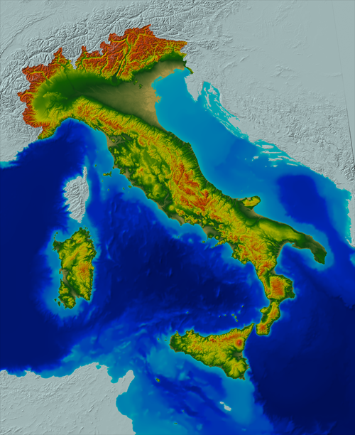
A seamless digital elevation model (DEM) of the whole Italian territory, originally named TINITALY/01 (also known as the "TINITALY" DEM, in short), was presented in 2007 (Tarquini et al. 2007*). The dataset is about the elevation of the bare ground, and thus it can be called a DTM (Digital Terrain Model). This DEM was obtained starting from separate DEMs of single administrative regions of Italy. The DEM is freely available as a 10 m-cell size grid (in GeoTIFF format), in the UTM WGS 84 zone 32 projection system (see the link download).
In January 2023, a new version of the TINITALY DEM is released, named TINITALY/1.1. In this version several inaccuracies of the former DEM are corrected. Along with the upgraded DEM, a suite of DEM-derived products are now available as WMS, WMTS and WCS services: (i) shaded relief map; (ii) slope map; (iii) Sky view Factor (SVF) map using 2.5σ clipping as technique for image enhancement; (iv) SVF map using equal area equalization as technique for image enhancement; (v) openness down map using equal area equalization as technique for image enhancement; (vi) Hue-Saturation-Value (HSV) composition image with slope (2.5σ clipping) as saturation and SVF (2.5σ clipping) as value according to RRIM (Red Relief Image Maps) style maps; and (vii) slope map using 2.5σ clipping as technique for image enhancement.
Download here the accompanying notes explaining the main novelties of TINITALY 1.1.
TINITALY is published with a CC BY 4.0 license and can be used freely, even partly, but it must be cited as follows.
Tarquini S., I. Isola, M. Favalli, A. Battistini, G. Dotta (2023).
Tarquini S., I. Isola, M. Favalli, F. Mazzarini, M. Bisson, M.T. Pareschi, E. Boschi (2007). TINITALY/01: a new triangular irregular network of Italy. Annals of Geophysics. https://doi.org/10.4401/ag-4424
For more information see:
- *Tarquini S., I. Isola , M. Favalli , F. Mazzarini, M. Bisson, M.T. Pareschi, E. Boschi (2007). TINITALY/01: a new Triangular Irregular Network of Italy, Annals of Geophysics, 50, 407-425. https://doi.org/10.4401/ag-4424
- §Tarquini S., Vinci S., Favalli M., Doumaz F., Fornaciai A., Nannipieri L., (2012). Release of a 10-m-resolution DEM for the Italian territory: Comparison with global-coverage DEMs and anaglyph-mode exploration via the web, Computers & Geosciences, 38, 168-170. https://doi.org/10.1016/j.cageo.2011.04.018
- Tarquini S., L. Nannipieri (2017). The 10 m-resolution TINITALY DEM as a trans-disciplinary basis for the analysis of the Italian territory: Current trends and new perspectives. Geomorphology, 281, 108-115. https://doi.org/10.1016/j.geomorph.2016.12.022